Spatial Intelligence Domains
Each domain represents a category of environmental information that can be captured, analyzed, modeled, and simulated.
Capturing the physical structure of the land to reveal the underlying dynamics of the landscape. High-resolution data is converted into analytical models that form the structural foundation for all environmental planning.
Key Datasets & Deliverables
- Digital Elevation Models (DEM)
- Digital Terrain Models (DTM)
- Digital Surface Models (DSM)
- Contour maps
- Slope maps
- Aspect maps
- Terrain roughness metrics
Analyses & Applications
- Slope stability analysis
- Landslide risk analysis
- Terrain segmentation
- Watershed boundary delineation
- Erosion risk mapping
- Construction feasibility analysis
Terrain intelligence forms the foundation layer for environmental modeling and planning.
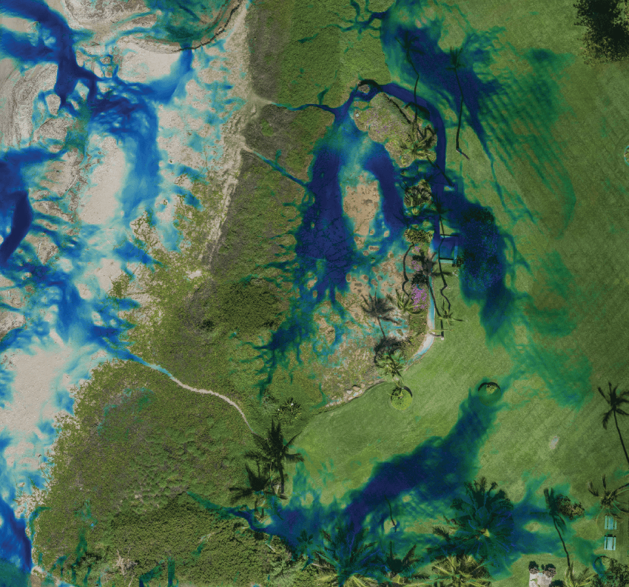
Mapping how water moves across landscapes to understand how terrain, soil, and climate interact. Understanding these interactions is essential for development planning, conservation, and climate resilience.
Key Datasets & Deliverables
- Watershed delineation
- Drainage network extraction
- Rainfall runoff modeling
- Flood modeling
- Flood risk analysis
- Erosion and sediment transport modeling
- Stormwater flow simulation
Analyses & Applications
- Watershed restoration planning
- Flood mitigation planning
- Stormwater infrastructure design
- Erosion control strategies
- Climate resilience planning
Hydrology intelligence helps stakeholders understand how landscapes interact with rainfall, rivers, and groundwater systems.
Analyzing the structure and distribution of plant ecosystems to understand their impact on soil stability, water retention, carbon storage, and habitat formation. Using LiDAR, photogrammetry, and ecological modeling, Levity analyzes vegetation systems at multiple scales.
Key Datasets & Deliverables
- Canopy height models
- Tree crown dimensions
- Vegetation density
- Understory distribution
- Biomass estimation
- Vegetation encroachment detection
Analyses & Applications
- Forest inventory and monitoring
- Agroforestry planning
- Regenerative agriculture systems
- Landscape architecture planning
- Habitat restoration
- Infrastructure corridor monitoring
Vegetation intelligence allows stakeholders to understand how plant ecosystems interact with terrain, hydrology, and human infrastructure.
Biospheric & Environmental Context
Integrating broader environmental and human systems — climate patterns, geological processes, cultural history, indigenous land management practices, and regulatory frameworks — into the spatial record. This ensures land stewardship honors ecological realities and deep cultural context.
Key Datasets & Deliverables
- Solar exposure analysis
- Microclimate site conditions
- Soil composition and drainage
- Bedrock structure mapping
Analyses & Applications
- Historical land use patterns
- Indigenous land management practices
- Cultural and historical landscape context
- Zoning and regulatory analysis
- Environmental protection compliance
Understanding these contextual factors is essential for responsible land development, restoration planning, and long-term landscape stewardship.
Creating data-accurate virtual representations of landscapes to test "what-if" scenarios. These risk-free environments allow stakeholders to explore the successional evolution of a site over decades before a single tree is planted.
Key Datasets & Deliverables
- Real-time hydrologic fluid simulations
- Successional vegetation growth modeling
- Interactive 3D site explorers
- Development scenario testing
Analyses & Applications
- Hydrology simulations (water flow, flood zones, erosion)
- Development simulations (road, building, grading)
- Ecological simulations (forest succession, agroforestry, habitat restoration)
Digital twins become powerful decision tools when combined with environmental simulations.